Google has collected and integrated photos and data from
satellites, aircraft, and cars to give us an incredible new way to look at our
world. Google doesn't shoot its
own images. There are a handful of companies that do that. But GoogleEarth has
designed software that knits it all together so it feels like we're zooming in.
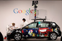
 GoogleEarth has an addition called "street level"
mapping. Basically it's a rig on top of a vehicle containing eight cameras,
covering a full circle as it slowly drives along, snapping digital images.
EARN A REWARD!
Learn to use GoogleEarth and complete these exercises.
You will need GoogleEarth on your computer to complete this
exercise. You are welcome to use a
computer in Mrs D's class. If you want to
install GoogleEarth on your home computer, BE
SURE TO FIRST GET PERMISSION FROM YOUR PARENTS. If you have not used GoogleEarth or just want to brush up on the features, click on this link to get short tutorials. http://www.google.com/earth/learn/beginner.html
To earn your reward, put your answers on paper and turn in to Mrs D before class time on Friday, September 7th. Have fun!
FIND PLACES AND THINGS
- Type in these LAT LON coordinates. 51.997915,8.49231 Who do you see at this location?
- Type in “Cape Cod”. Zoom in on the northern tip of the cape. What is the name of the town?
- Type in your street address. Does GoogleEarth have a view of your house (yes or no)?
TURN ON LAYERS TO GET MORE INFORMATION
- Turn on layers for volcanoes (under Layers - Gallery). Now go to the island of Hawaii. How many volcanoes are on this island?
- Turn on labels for webcams.travel. Now search on Martha’s Vineyard and find the webcam for Martha's Vineyard, Edgartown Harbor from the Vineyard Square. Click on the webcam….. write down what you see in the webcam photo.
MARK SOMETHING WITH A PLACEMARK
- Find a place that interests you. It might be your house, or a ball field, or the Statue of Liberty. Add a placemark at this location and give the placemark a name. For example, Mrs D put a placemark on Bryant-Denny stadium in Tuscaloosa and added the name “Cam owns this place!” Print a copy of your GoogleEarth screen showing your placemark or just record what you did on your paper.
MEASURE A DISTANCE
Using the ruler tool, measure the distance of the longest
runway at John F Kennedy airport in New York.
- State the distance in feet.
- State the distance in miles.
USE STREET VIEW
Type in the address 212 S Halsted, Chicago, IL. Now go to Street View and look
around.
- What business is located at this address?
Now congratulate yourself for learning how to use GoogleEarth and for earning a reward!
